
The Norwegian Scenic Route – Ryfylke – starts in the south from Oanes at the mouth of the Lysefjord – to Håra near Røldal in the north, around 260 km.
The route follows Rv13 with another branch travelling via Sauda and over the impressive Saudafjellet mountains.
The Norwegian Scenic Route Ryfylke has it all! It takes you along a varied landscape; from the archipelago, moors, and lush hillsides,- to deep fjords, steep mountains, and waterfalls.
The road provides access to many nice and modern recreational areas, some with a beautiful view. There are lots of opportunities on the way to make short detours and to take a break from driving, whether you are keen to explore one of the lovely little shore villages or take one of the many hikes in this area.
RYFYLKE – PART 1:
Oanes – Hjelmelandsvågen
This is the first part of the scenic route include travelling through the municipalities of Strand and Hjelmeland. Starting in Oanes in the south – to Jøsenfjorden in the North. The main attractions in this part:
- Forsand – Landa prehistoric village
- Høllesli-Lysefjorden
- Preikestolen – Pulpit Rock – detour
- Rock carvings – Solbakk
- Årdal Old Church
- Hauske rest area
- Vigatunet
- Hjelmelandsvågen
STRAND MUNICIPALITY
Oanes where the route starts from is located in the south of the municipality of Strand. Strand enjoys excellent access to the fjord and sea, as well as beautiful mountains and heaths.
This area is located across the fjord from the city of Stavanger. The Ryfast tunnel system connects Stavanger and Strand by a very long undersea tunnel.
Oanes is a small village located at the intersection between the Lysefjorden and Høgsfjorden. From Oanes you can go by ferry to Lauvvik across the Høgsfjorden. This is a part of Rv13.
Departing from Oanes you soon pass Lysefjordcentre which has tourist information, a restaurant, and conference facilities. From this centre, there is a beautiful view of Lysefjordbrua. This is a 639-meter-long suspension bridge over the Lysefjorden and connects the municipalities of Strand (on the north end of the bridge) and Sandnes (on the south end ).

I also visited Forsand, – the first village after crossing Lysefjord Bridge. The biggest attraction here is – Landa Park – a prehistoric village

Landa Park – has reconstructed houses from the Bronze Age and Iron Age.
The archaeological discoveries at Landa are unique; a largely residential area with around 250 houses! It is the first known bronze age village in Norway – dated back to about 1500 BC until about 600 AD!
The park was closed when I visited the place. When it is open, from mid-May to September, you can see history come alive and participate in fascinating activities. Landa Park has also a campsite.
HØLLESLI – LYSEFJORDEN
Back on Fv523, at Høllesli, just past the bridge, there is a great viewpoint. Take a stop and enjoy the beautiful view of the Lysefjorden:
PREIKESTOLEN – THE PULPIT ROCK
Further along this fjord, you will find the famous Preikestolen – the Pulpit Rock – the cliff which rises 604 m (1,982 ft) above the sea-
and has a breathtaking viewing platform. It is not only the highlight of Ryfylke and Rogaland – but one of Norway’s most visited attractions.
Another great detour – is to explore Lysefjorden by ferry which stops at Lyseboth at the end of the fjord.
More of my hike to Preikestolen:

Just 8 km north of Hølleli,
4 km south of the Jørpeland, you will find the exit to the Preikestolvegen – and it is 5 km to the parking lot.
If you have time- this is absolutely worth a visit. The hike to Preikestolen will take you about 2 hours each way.
Jørpeland – became designated as a town in 1998 and is the administrative centre of Strand municipality. It is known as “Pulpit Rock City” because it is the nearest city to the Preikestolen, which is the biggest attraction in this area.
Jørpeland has also tourist information, a cultural centre (Torghuset), a harbour in Vågen with boardwalks, and various restaurants.


SOLBAKK – Prehistoric rock-carvings
At Solbakk – just a couple of km north of Jørpeland – you will find a prehistoric rock-carving site. The rock slope is near the sea, close by RV13.
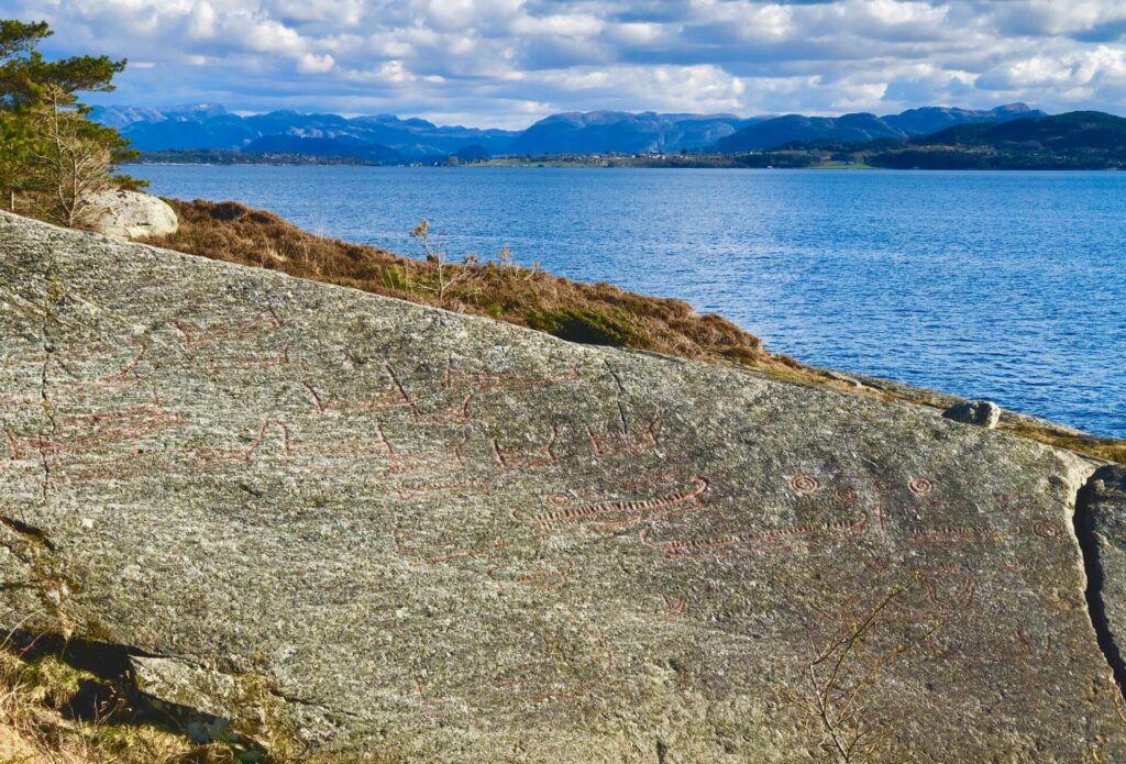
The rock carvings date from the Bronze Age – around 500 BC.
Carvings of ships predominate. Both ships and circles (suns) are carved into the rock. All in all, there are nearly 30 ship-carvings and 8 sun figures. Some of the ships have enclosed hulls, others open. The vertical lines in the ships depict the crews. The suns are circle-shaped with smaller circles inside. All the carvings are highlighted.
Just north of Solbakk, the Ryfast tunnel has its eastern entrance. From here you can reach Stavanger in 30 min. Rv13 starts from here – going north.
After passing Tau, you will pass 2 lakes, first Bjørheimsvatnet, then Tysdalsvatnet. Nice view of Tysdalsvatnet from Tysdal Camping at the end of the lake:

HJELMELAND MUNICIPALITY
My next stop was Årdal – and the old Årdal church. This church is located in Hjelmeland Municipality.
Hjelmeland municipality is known for its fruit and fish production. Salmon has been important for the fish industry in Hjelmeland for a couple of decades, but white fish such as cod and halibut has increased their value in the later years.
Hjelmelandsvågen as its administrative center. Other villages include Fister, Årdal, and Jøsenfjorden.
Årdal Old Church is one of the top attractions in this area.

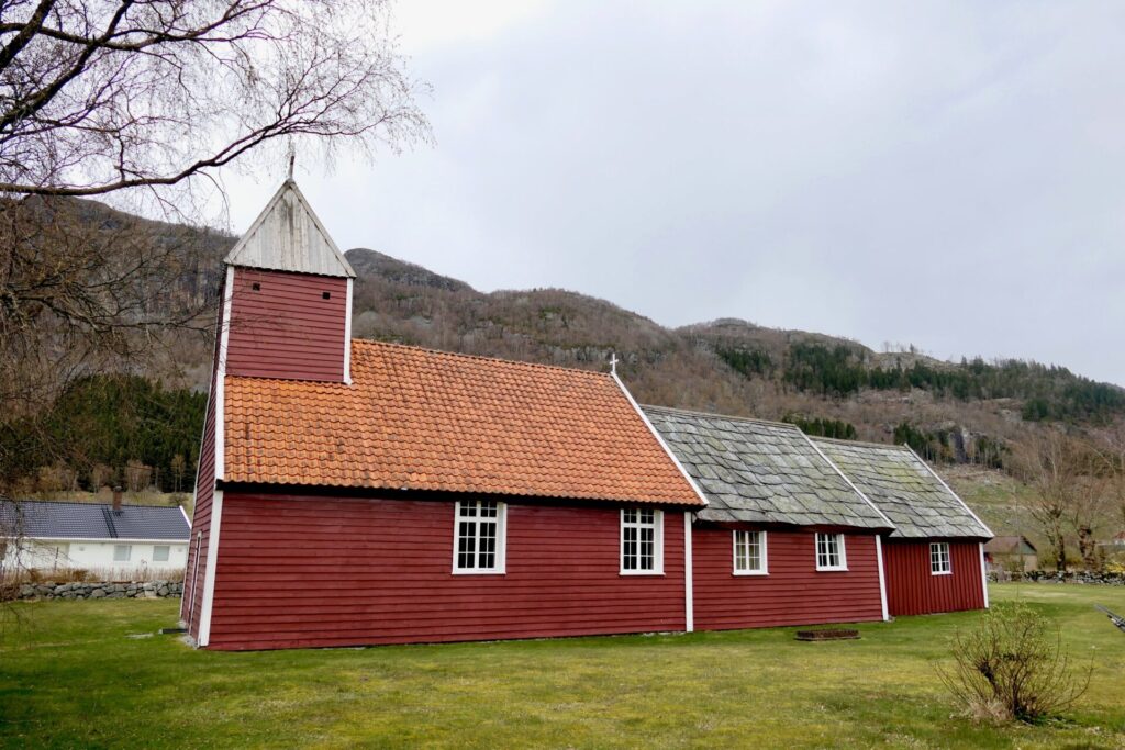
Årdal Old Church
A distinctive renaissance church from the 17th century! The church was built in three stages, the first stage in 1619, the next one in 1626 and 1709.
At this site, a stave church existed. It was likely built during the 13th century. The church was torn down in 1619 and a new church was built – using some of the reused materials from the previous church. Part of the foundation under the southwest corner of the church was the same foundation for the medieval stave church.
I visited this church at the end of April this year – and was very glad to see the key was in the door! So I could have a look around – I was thrilled!
I had only read about its special interior – and I was very surprised watching the special and beautiful paintings inside, the church has many beautiful painted decorations of prophets, angels, and flowers.
The church was marked by the work of two local artists, the German painter Gottfried Hendtzschel and his student, craftsman Lauritz Snekker. The altarpiece and the pulpit were painted by Hendtzschel. They are made of Thomas Snekker who is also responsible for most of the carpentry work. The artistic efforts of Hendtzschel and Snekker within various churches in the vicinity formed a part of the Stavanger Renaissance, the cultural period which peaked in the middle of the 17th century in the area around Stavanger, Norway.

On the top of the hills towards Hjelmelandsvågen- a nice little rest area – with a view to Hetlandsvatnet. Also informasjon of Hjelmeland Community
HAUSKE REST AREA
A short drive further – another picnic area – HAUSKE – with a historical Stonebridge and a rural grinding mill
VIGATUNET – Old Farmstead
Viga is an old farm situated by a bay, just before reaching Hjelmeland Quay.
Take the road Fv631 southward, and follow the signs.

VIGATUNET
VIGATUNET is a well-kept old farm complex. As it stands today it dates from 1821 but the oldest of the buildings, the smokehouse, was built in the 1600s.
The farm has a dwelling house, cookhouse, storehouse, and barn.
Vigatunet is part of Ryfylke museum
Viga employed many servants. The basis for operations here was arable farming and animal husbandry.
It is believed that it was settled at least a couple of thousand years ago. There are numerous burial mounds on this site with finds dated to the Viking Age. Written sources on the farm reach back to the 1500s.
In 1990 a historical orchard was opened, where old varieties of fruit and the rich fruit traditions of Hjelmeland are preserved. The roofs with slates from local slate quarries are a distinctive feature of Vigatunet.
Back on Rv13, Hjelmelandsvågen in sight, and the ferry Hjelmeland-Nesvik:

HJELMELANDSVÅGEN
Hjelmelandsvågen– is the administrative centre of the municipality of Hjelmeland. The village is located on the south side of the mouth of the Jøsenfjorden. Some of the attractions:
-Word´s largest JÆRSTOL
-Beautiful white wooden houses
-Hjelmeland Church – long church design from 1858
-Spinning mill (1873) with a versatile history
Hjelmeland is known for the production of traditional chairs, called “Jærstol”. By the river mouth and harbour, you can see the world’s largest traditional chair – Jærstol! It is about 4,5 m high and was built in connection with the 100th anniversary of the start of traditional chair production.
This type of chair is a classic in Norwegian furniture production, and you can find them all over the country. Hjelmeland has been the most important city in Norway when it comes to the production of these chairs. Nowadays there is only one producer left in Hjelmeland: Aksel Hansson AS.

The Jærstol by the river and the Hjelmeland Bridge. To the right, an old spinning mill with a versatile history. It was built in 1873-74 as a wool spinning mill., from 1919 – used as a cannery, and in early 1930 the production of chairs began in this same building.
After the war, various activities took place in the building: clog factory and fruit warehouse among others. Around 1990 the town hall bought the building and restored it for cultural purposes.
The National Rv13 continues from Nesvik, north of Hjelmelandsvågen – and is connected with a ferry across the Jøsenfjorden. This is the only ferry connection for this scenic route.

JØSENFJORDEN
From Nesvik the National Rv13 runs along the northern shore of Jøsenfjorden. Jøsenfjorden is a branch off of the main Boknafjorden and the fjord has a length of 24 kilometres to the inner village Førrebotn.
On both sides of the fjord, there are mountains up to 700 meters, but there are still some farms and crofts. If you want to visit Førresbotn, you will have to go by boat.

The view can also be admired from Skomakarnibbå south of the fjord.
Can you see the small mountain top in the middle of the photo beneath?
It looks very small from the other side of Jøsenfjorden, but it is a very popular hike and a great view from the top. If you want to take the detour, it is 15 min. drive from Hjelmelandsvågen, and 6 hours hike t/r

This is how the Skomakarnibbå looks like when you are at the top:
(https:/mitt-hjelmeland.no)
Rv13 follows the fjord about 13 km before turning north towards Erfjord. This is along Kilavågen:

The route continues on Norwegian Scenic Route-Ryfulke part 2:
